
Bellin Canarie 1746(HM27)
価格帯: ¥12,800 – ¥88,800 税込
1746 BELLIN CANARIE
1746 BELLIN CANARIE
1746 Bellin Canarie
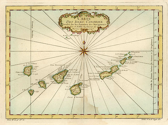
This superior reproduction of the original antique hand colored copperplate engraved map of “Carte Des Isles Canaries” by Jacques Nicolas Bellin, Hydrographer to the Crown of France, was originally published circa 1746 in Histoire Generale Des Voyages. Bellin surveyed all the known coasts of the world after being appointed Ingénieur Hydrographe de la Marine in the French Hydrographic Service. This detailed map of the Canary Islands off of Northwest Africa is decorated by a splendid cartouche, rhumblines and compass rose.
プリントサイズ
基本のプリントサイズは全部で5種類です。作品によっては、表示されているサイズ以外でカスタムオーダーが可能です。カスタムオーダーでお好みの大きさでご注文希望の場合には、カスタムオーダーリクエストよりお問合せください。
| 表示サイズ | プリント内寸(cm) |
| SS | 20.3×25.4cm(8×10インチ) |
| S | 30.5×40.6cm(12×16インチ) |
| M | 40.6×50.8cm(16×20インチ) |
| L | 50.8x61cm(20×24インチ) |
| LL | 61×76.2cm(24×30インチ) |
●内寸=イメージ部分のサイズとなり、プリントのみご注文の場合には、上記サイズより上下左右、各5cm前後の白い余白があります。
●サイズは、US単位(インチ)を基準としてcmに換算しておりますので、若干の誤差が生じます。
(税込)
| サイズ | プリントのみ | 木枠マウント加工 |
| (SS)20x25cm | ¥12,800 | ¥19,800 |
| (S)30.5×40.6cm | ¥15,800 | ¥23,800 |
| (M)40.6×50.8cm | ¥22,800 | ¥38,800 |
| (L)50.8x70cm | ¥38,800 | ¥58,800 |
| (LL)70×76.2cm | ¥54,800 | ¥88,800 |
*サイズはUSインチをcmに変換しておりますので、若干の誤差がございます。
USサイズは下記の通りです。(単位=インチ)
(SS)8×10(S)12×16 (M)16×20 (L)20×24 (LL)24×30
| プリントサイズ | (SS)20x25cm, (S)30.5×40.6cm, (M)40.6×50.8cm, (L)50.8x70cm, (LL)70×76.2cm |
|---|---|
| フレーム加工 | なし(プリントのみ), 木枠マウント加工 |
“Bellin Canarie 1746(HM27)” の口コミを投稿します
レビューを投稿するにはログインする必要があります。
関連商品


レビュー
レビューはまだありません。